
Toledo HEC Flood Hazard Visualizer Visualize how climate change and green infrastructure could impact flood damages on the property level.
Material type: TextContent type:
 - text
- unmediated
- volume
| Item type | Current library | Call number | Status | Date due | Barcode | Item holds |
|---|---|---|---|---|---|---|
 Online Resources, E-resources
|
ASFPM Library | Available |
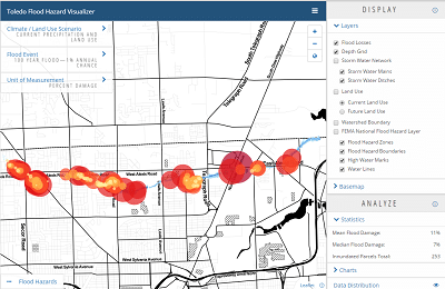
For decades the City of Toledo, Ohio has been adversely impacted by persistent annual flooding. Widespread damages to homes, business, and public infrastructure coupled with local economic decline has driven city officials to begin searching for alternative ways to mitigate flooding. In 2012, the City of Toledo, NOAA, ASFPM, ERG, and USACE partnered together to evaluate if green infrastructure would be a cost-effective solution. The Toledo Flood Hazard Visualizer was developed to communicate the results of this study titled "Economic Assessment of Green Infrastructure Strategies for Climate Change Adaptation: Pilot Studies in the Great Lakes Region". With this tool, users are able to visualize how climate change and green infrastructure could impact flood damages on the property level.
Features:
Compare flood damages across different climate scenarios
Evaluate how green infrastructure impacts flood losses now and in the future
Share visualizations with others who are interested in learning more via exportable PDFs and links
Access the study data through our data portal
Staff. Public.
Protected by copyright law.
There are no comments on this title.